Unlocking the Potential of the Celtic Sea through detailed Habitat Maps
- David Lamb
- Jul 14, 2025
- 3 min read
Updated: Sep 3, 2025
The Celtic Sea holds immense potential for floating offshore wind development, yet it hasn’t been mapped as thoroughly as other areas. Thus, understanding its complex seabed habitats remains a critical challenge. That's why we're excited to share the first results from our OceanIQ project – an initiative that's transforming how we map and understand marine environments even beyond the Celtic Sea.
This is the first in a series of updates documenting our journey to develop comprehensive marine habitat maps for the Celtic Sea.
A New Chapter in Marine Habitat Mapping
Thanks to an Innovate UK Launchpad South-West Wales grant, we're embarking on an ambitious 12-month journey (May 2025 - April 2026) to create higher resolution seabed habitat layers than those currently available for the Celtic Sea.
Our lead oceanographer, Kate, has been leading the development of a machine-learning framework that integrates traditional grab-sample observations with open-source bathymetry seafloor current datasets. The goal? To predict sediment composition across the Celtic Sea with unprecedented accuracy and resolution.
The Science Behind the Sediment
Understanding sediment composition – the mix of mud, sand, and gravel on the seafloor – is fundamental to habitat classification. These seemingly simple categories determine which species can thrive in different areas and influence everything from benthic community structure to cable burial feasibility.

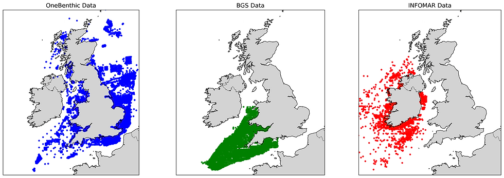
Our approach leverages three major datasets:
OneBenthic: Contributing over 33,000 observations
INFOMAR: Adding 2,748 samples from Irish waters
British Geological Survey: Providing 5,983 additional data points
Together, these datasets give us 41,752 observations to train our models – a robust foundation for machine learning applications.
Beyond Traditional Sampling
What makes our approach innovative is the integration of multiple environmental covariates. We're not just looking at sediment samples in isolation; we're considering:
Bathymetry metrics: Including depth, aspect, and local variability
Bottom currents: Mean, maximum, and variability in seafloor velocities
Distance to coast: A critical factor influencing sediment transport
Depth-integrated speed: Capturing the full water column dynamics

Machine Learning Meets Marine Science
We've implemented both Random Forest algorithms, using spatially-aware cross-validation to ensure our models generalise well across the Celtic Sea. This isn't a black-box approach – we're carefully evaluating model performance and understanding which environmental factors drive predictions.

Early results are promising, showing coherent spatial patterns that align with our understanding of Celtic Sea dynamics. Sandy sediments dominate the central areas where strong tidal currents prevent fine material from settling, whilst muddier sediments accumulate in deeper, calmer waters.
Real-World Applications Driving Innovation
This work isn't happening in isolation. We're developing these layers specifically to address industry needs:
Offshore Wind Developers: De-risking Environmental Impact Assessments by providing baseline habitat data
Conservation Planners: Supporting evidence-based Marine Protected Area management
Government Agencies: Offering a trusted biodiversity baseline for policy decisions
Marine Insurers: Enabling better risk assessment for offshore infrastructure
Looking Ahead
This sediment modelling represents just the first step in our ambitious roadmap. We'll be:
Classifying data according to Level 3 JNCC habitat categories, translating sediment types into ecologically meaningful habitat classifications
Feeding in species distribution models to achieve Level 4 JNCC habitat classification, adding biological complexity to our physical baseline
Applying ecosystem service models to assess restoration potential and carbon sequestration capacity of different habitats, supporting nature-based solutions and blue carbon initiatives
The Celtic Sea sees ambitious targets for blue economy activity and at the same time it is not as well mapped as other waters around the UK. By combining machine learning with decades of marine sampling data, we're building the tools needed for sustainable development. Our OceanIQ project demonstrates that with the right approach, we can transform scattered observations into comprehensive understanding.
We're committed to open science and will be sharing our methodologies and findings throughout the project. This transparency not only advances marine data science but ensures our work can be validated, improved, and applied in other regions facing similar challenges.
Stay tuned for our next update, where we'll dive into the ecological interpretation of these sediment maps and their implications for benthic habitat classification.
For more information about the OceanIQ project or to discuss collaboration opportunities, please contact hello@oceanos.earth


Comments